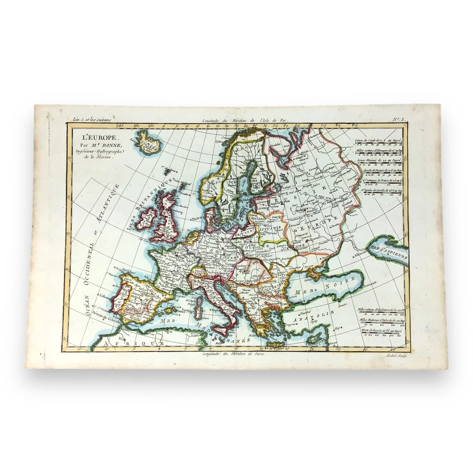
Antique Hand-Colored Map "L'Europe" by Rigobert Bonne, 1780 - Copperplate Map
This is an Original Antique Map of Europe, created by Rigobert Bonne in 1780. Bonne was a prominent French cartographer known for his detailed and artistic maps.
The specific map was printed using the copperplate engraving technique and features hand-colored borders distinguishing the various countries and regions.
This is an unframed, original paper map, showcasing minimal signs of age with extremely well-maintained color and detail.
This well-preserved map is an exceptional example of Rigobert Bonne's cartographic craftsmanship, perfect for history enthusiasts or those who want a hand-crafted piece of history!
Key Features:
- Upper right corner marked "No. 3", and upper left reads "Liv, I, er les susvans". The lower right includes the engraving credit "Andre Sculp"
- The map displays the state of Europe in the late 18th century, showcasing political and geographical features of the time
- The borders and country regions are carefully hand-colored, showcasing vivid detail and remarkable preservation
Condition: Excellent antique condition with a vertical center fold, typical of maps from this period. The hand-coloring has been remarkably preserved, highlighting the historical accuracy and vibrant illustrations.
Item Dimensions:
- Map Size: 9.75" H x 15" W
Location: Collectors Crossroads - QM0091
Original: $290,200.00
-70%$290,200.00
$87,060.00Product Information
Product Information
Shipping & Returns
Shipping & Returns
Description
This is an Original Antique Map of Europe, created by Rigobert Bonne in 1780. Bonne was a prominent French cartographer known for his detailed and artistic maps.
The specific map was printed using the copperplate engraving technique and features hand-colored borders distinguishing the various countries and regions.
This is an unframed, original paper map, showcasing minimal signs of age with extremely well-maintained color and detail.
This well-preserved map is an exceptional example of Rigobert Bonne's cartographic craftsmanship, perfect for history enthusiasts or those who want a hand-crafted piece of history!
Key Features:
- Upper right corner marked "No. 3", and upper left reads "Liv, I, er les susvans". The lower right includes the engraving credit "Andre Sculp"
- The map displays the state of Europe in the late 18th century, showcasing political and geographical features of the time
- The borders and country regions are carefully hand-colored, showcasing vivid detail and remarkable preservation
Condition: Excellent antique condition with a vertical center fold, typical of maps from this period. The hand-coloring has been remarkably preserved, highlighting the historical accuracy and vibrant illustrations.
Item Dimensions:
- Map Size: 9.75" H x 15" W
Location: Collectors Crossroads - QM0091